


The ever-changing map of the Louisiana coastline
We're used to boundary changes, but in Louisiana there's an extra dimension to consider

Maps change over time. The boundary lines for counties or parishes, states, and even countries are not as constant as one might expect them to be; new zones are defined, existing ones are merged together or resized, and location names change over time as society does. All this change can present a challenge for genealogists trying to figure out where exactly their ancestors lived; sometimes it can appear that people were moving around when, in fact, they remained stationary and the map changed around them. Sometimes people are exactly where we thought they should be, but we didn’t realize that for the time period we are searching, the land technically was part of another state. You get the picture. :-) Maps are important for genealogy.
Louisiana has a unique history, having been a French colony, a Spanish colony, and eventually an American colony and later state. Each reigning government had its own preferred methods for land administration. Some historical remnants are still visible today in place names and in the shapes of the plats carved out of the land. This is further compounded by the fact that, in Louisiana, the land itself is changing, and rapidly. Coastal erosion is occurring quickly enough in Louisiana that there is a striking difference between historic maps drawn in the 1800s and what exists today, a mere 200 years later. The land your ancestors lived on, if they lived in south Louisiana, could literally be open water now.
The following image was taken from the Terrebonne Parish Assessor’s Office plat map application to show a lower section of the parish.
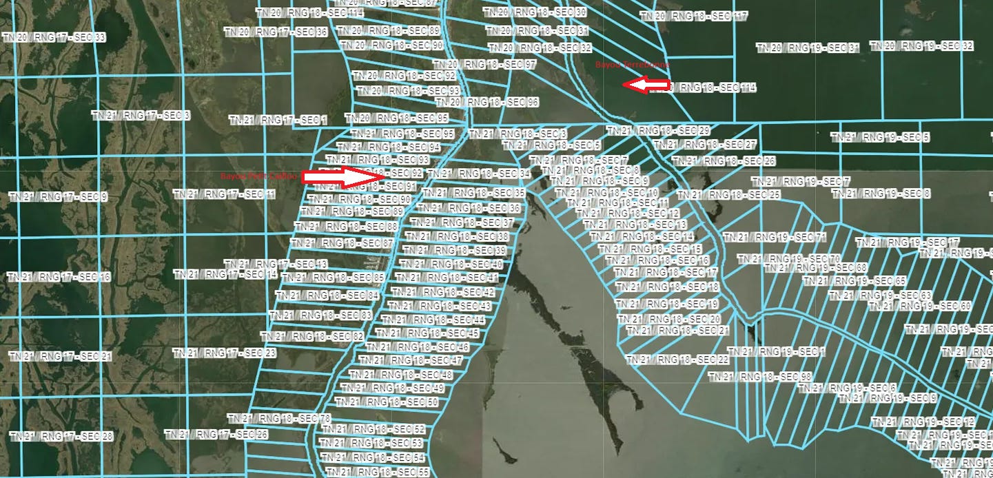
Sorry for the potato quality image edits, but hopefully you can see the two arrows I added pointing out Bayou Petit Caillou on the left and Bayou Terrebonne on the right.
The next image is from the Louisiana Office of State Lands database. It’s an 1832 plat map of the same area as the previous image. You can see Petit Caillou labeled on the left and Bayou Terrebonne on the right (the name is cut off except for “Bonne”).

Now, the same image from the Assessor’s Office site, but without the overlay showing the plats.

You can see where Petit Caillou runs in the satellite image based on the buildings running along it in a line on the left side. Bayou Terrebonne is also visible, but only barely. (It’s circled.) There’s certainly no “lake” as depicted in the 1832 version of the map. It appears that that “lake” is now just part of the Gulf.
It took me a good amount of time just to be sure that I was looking at the same part of the map as that depicted on the 1832 map. The map’s biggest landmark, a lake, has ceased to exist!

This image was taken by moving just a bit further south on the map.

Without the overlay, you can kind of see in the top left of the image where the bayou runs, although it’s being slowly eaten by the Gulf and will soon no longer be visible as a landmark at all. What strikes me about this comparison is that there are plats extending this far down the bayou at all. The satellite image shows scant land in the area, most of this is open water. However, the fact that there are plats on either side of the bayou this far down suggests that when they were originally surveyed, this was land.
Here’s an old map showing the southern coast of Louisiana in 1853.

Check out the islands at the bottom part of the image. You can see Last Island is quite large, to the east of Last Island you can make out Caillou and Timbalier Islands. The barrier islands are chained together in a line, nearly touching each other.
Satellite image taken today from Google Maps:

I’ll zoom that in so it shows the actual labels for the islands:

“Isles Dernieres” is the French name for Last Island. You can see its remnants on the left side. You can also see Timbalier on the right side. Caillou Island is labeled on the map, but there’s no actual island there anymore. Just water. Many of the lakes in the area are still noted on the map, but I don’t think someone surveying this land for the first time today would distinguish them as such. They are all bleeding into each other and the swamp now.
I zoomed in some more on Caillou Island.

There are a few old industrial-looking structures there, but they appear to be sitting in the water, not on an “island”. Caillou Island used to be “huge, nearly as large as the modern city of Houma”.
I had never heard of Caillou Island until I found an old newspaper article which features a brick wall ancestor of mine acting as a guide for the author of the article, bringing him down to Caillou Island in 1836.

“Mr. Gautier” was the patriarch of my unfortunately-fated Gautier line. His son was the father of all those siblings in my earlier article. I tried to learn more about Caillou Island and locate it on the map, but found it had sunk into the sea. I was able to find more mentions of what used to be there in old newspaper articles such as this one in an advertisement selling a plantation in the area.

Apparently there were buildings on the island, and it was a popular resort area for families. That ad was placed in 1835.
In 1855, an ad was placed by Joachim Porche, who was opening a hotel on Caillou Island.

My guess is that all hopes for Caillou Island’s further development as a sea resort were dashed the following year, when the formidable and much-written-about Last Island Hurricane struck and destroyed several barrier islands, including Last Island, which had already been considerably developed for that purpose. That hurricane is to this day considered the strongest hurricane to make landfall in Louisiana ever, tied with hurricanes Laura and Ida (from the 2020s).
I think comparing old maps of south Louisiana is super interesting. It’s also sad. Much has been lost to coastal erosion and saltwater infiltration. Cemeteries that once existed on land are now submerged, never to be seen again. We have a limited amount of time to try to learn all we can about the people that once lived in these areas, because the evidence is quickly disappearing.
I love looking at maps and haven't considered how the land has changed until I looked at one line I want to explore more - Japp from Jappsand in the Weddell Sea off Denmark/Germany. The location shows as a bird sanctuary now and this reminds me to look for older maps
Fascinating look at a topic I haven’t really thought much about in my own genealogy research. Thanks for putting it in my radar!